Dave and I headed over to Aspen again to try for Castle and Conundrum Peaks. We had the same plan as the week prior, but with the more unsettled weather due in saturday afternoon, we decided to start out a little earlier on saturday morning. The weather on the drive over was fantastic, few clouds, but now precip, and fairly warm. The 4wd road was fairly devoid of people and the campsite choices were plentiful. When we got to treeline, approximately where our camp was a week earlier, we decided to continue driving to the end of the road at 12,800 feet, to scope out the conditions and get a glimpse of our route and the peaks. From camp, you cannot see either mountain, nor the actual climbing portion of the climb. It was awfully tempting to stay there and camp for the night, but abiding by mountaineering standards, we elected to drive back down to the trees and camp there; allowing for at least 3,000 vertical feet of climbing, versus the 1400 feet from the end of the jeep road. We camped at the last campsite at treeline. The evening was really nice with clear skies and plentiful stars. A half moon lite the basin with a warm white glow. We ate a quick rommen meal and hit the sack. Around 430am, Dave wakes me up. He seemed pretty tired and expressed that he had had a really rough night sleeping and didn't quite feel into the climb. We decided to push on and see if things would improve with his health. From our camp to the end of the road is roughly 2.25 miles and 1800 feet of elevation gain. The route follows the jeep trail in it's entirety. From there, a couple of routes can be taken. As the darkness began to give way to the morning glow, we continued to hike up the steep and rocky road, slowly gaining elevation. Dave continued to have difficulties with his health, which as we went on, became worse and worse. It was not the same sickness the ailed him from the week prior. This one gave the appearance of a bad cold or flu. The sun finally rose as we put away our headlamps, and awaited the rays to hit our cold bodies. We continued to push on, hoping that things would improve. But, it was inevitable. Dave was sick, and going on would do nothing for us, other than give us the experience of a mountain rescue. Which we did not need to experience. We made it to the end of the road, contemplated our situation and Dave's health. The mountain God's warned us to not continue. So, we headed back down. We briefly chatted with several small groups of hikers coming up the road as we descended. The last group we encountered was a group of 5 hikers that we met at our camp. The funny thing about their group was that it was roughly 9am and they still had a lot mountain to climb before the weather would turn on them. I can only hope that they made it back to the safety of the trees before it hit. The packing up and driving home was uneventful, with the necessary food stop in Buena Vista. The weather did change quickly. As we drove home, the clouds thickened, and rolled in from the west and northwest. Lightning and heavy rain would accompany us from Wilkerson Pass into Woodland Park, and it was not even an hour after I got home that it dumped. Below is a few pictures from the trip. We hope to go back again soon and try to summit these two mountains that have alluded us for so long.

Independence Pass westbound at Twin Lakes

Independence Pass westbound towards Star Mountain, 12,942'

Independence Pass westbound towards La Plata Peak, 14,361'

Castle Creek Road southbound towards Taylor Peak (13,435') and Star Peak (13,521')

Along Castle Creek 4wd Road, Tagert Hut, part of the 10th Mountain Division and Summit Huts Association network of huts

Waterfall cascading down from Montezuma Basin, where we'll be camping and climbing

End of the jeep road and the beginning of the climb, friday evening

Same place as previous photo, but looking back down Montezuma Basin and Malemute Peak

Dave and his Jeep at 12,800 feet
The remainder are of the hike up on saturday.

Ah, darkness turns to light, mornings are my favorite

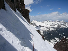
The lower flanks of Castle's Southeast Ridge

Upper Montezuma Basin ablaze with alpenglow. Conundrum Peak is center.

Conundrum Peak on the left

The end of the jeep trail.

Upper Montezuma Basin

Looking back down from high up in Montezuma Basin

Conundrum Peak from below Montezuma Glacier

Castle, left distant, northwest ridge, and Conundrum on the right

Conundrum Peak and lower part of Montezuma Glacier

A little wildflower action above treeline amidst the rocks

Our cozy campsite

self portrait

Another view of our camp
The last two of Castle Creek waterfall along the jeep trail back down to Ashcroft.


No comments:
Post a Comment