Thursday, July 30, 2009
Mt. Belford and Mt. Oxford plans
It is looking like that for this weekend, I will be climbing Mt. Belford and then traversing over to Mt. Oxford. I will be meeting up with Paul and possibly Dave tomorrow afternoon and then we will backpack up to treeline and camp out there for the night. The stars that are out high in the mountains are amazing! It is too bad I don't have the equipment to take pictures of it, as it is quite a sight to see! The backpack in to treeline will cut the distance down considerably, making the traverse over to Oxford more practical. Espically for me, as I am the slow one!
Monday, July 20, 2009
Mt Massive on July 18th, 2009
Mt Massive stats:
Summit Elevation: 14,421 feet
Trail Head Elevation: 10,500 feet
Total Elevation Gain: 3,950 feet
Total Roundtrip: 8.0 miles
North Halfmoon trail head
Dave and I met up with Paul at the North Halfmoon trail head just as the sun was setting behind the divide on friday. We had barely enough light out to pitch our tents and start dinner. The morning was going to start really early, so soon after we ate, it was lights out. Dave came over to my tent at 3:45am to wake me up, so that we could eat breakfast before our 4:30am departure. With very little moon light out, the forest was dark and kinda creepy. Both Dave and Paul had LED headlamps, as I only had a regular headlamp that the batteries were mostly dead on. Trying to keep up with the steady march that Paul led us on, seemed difficult, at best. Throughout the hike to the trail junction, I felt sick to my stomach and dizzy. At one point, I had to sit down to keep myself steady. By the time we got to the junction, I was feeling aweful and I thought that my hike was coming to an end rather quickly.


Mt. Elbert from the junction
The morning light began to fill the valleys and a slight tint of alpenglow warmed the ridges and summits. I insisted that Paul and Dave leave me and continue on to the summit. I told them there was no need for an emergency evacuation, and that they should, and have to go on. I explained to them that I would 1. be back at the tent resting, 2. hiking back down, or 3. climbing upwards towards the summit. Either way, I would be on the trail somewhere and not wondering off into the woods searching for trout uncaught. As they hiked on, I began looking for a suitable spot to sit for awhile and asses my condition. I munched on a few snacks and drank water. The shadow of Massive and the cool wind brought chills to my body as I sat and pondered my situation. As I got colder, I decided that the only way to stay warm was to keep moving, either up or down. It didn't matter much to me at the time, I just wanted to get warm. Curious as to way was around the next upward bend in the trail, I made my mind up that I would continue up, and that if I felt dizzy enough to sit down, then it would be finished. Period!


As I climbed higher and higher, the views got better and better. I had made my way to treeline and still felt pretty good. Climbing mountains is difficult, but climbing for no apparant reason, is well, pointless. I had to set myself a goal, or the journey would be tiresome and long. I assesed my condition again and considered the ridge as a good goal. A little out of reach, but not inpossible. To me, that is what a goal should encompass.
High above the valley below, the summit and it's long ridge were still out of sight. I continued at a very slow pace, having very little concern for the weather. The forecast for saturday was calling for a 10% chance of thunderstorms, but mainly warm and clear. With no clouds at any level and endless daylight, there truthfully was no reason to worry about the weather. Except for sunburns, which I always seem to get. I suppose it is my foregetfulness, or possibly my lack of something else. I should have brought sunscreen. Maybe after getting burned twice, I will remember it on the third. At about 12,500 feet, I met Dave on his way down. Interested in the distance to the ridge, I probed for answers; only to find out that the trail he and Paul took to the ridge, was not really a trail, but a loose and unstable gully. He had climbed the gully and spent quite some time looking for a trail on the ridge, leaving himself exhausted to the point of sickness. He felt his best option was to go back down. He told me that he was very surprised to see me that high and thought that I was finished. I explained to him that I had regrouped myself and felt tired, but overall, good. At somepoint during our discussion, a fairly large group of climbers passed us headed up. Dave decided to head down, as I continued up towards the ridge. It was not too long after that, that I caught up with the large group. It was a very strong group of climbers. At the tail of the group, I found a place get into line with. It was not long after I joined their group, that it became apparant that me and another member were not as fast as the rest of them. Together we pushed, each as tired as the other. Often, we would count aloud a predetermined amount of steps that we would hike until we could stop. Then we would rest for the same amount of heartbeats. It started out as 25 steps, then 30, 50, and finally 70 plus. Climbing can sometimes be a little mundane, as the goal is not always visible, so climbers have to do something mentally to keep going. Otherwise, it is just too easy to quit and turn back, leaving your goals and dreams high above.

Karen, after reaching the ridge. The summit is not in view yet.

Karen, as I told her not to jump!

And this is what she was looking down at, the west face of Massive towards North Halfmoon lakes and beyond.
Upon toping out on the ridge, I realized that I had made it that far, and that the summit was not too far out of reach. Why turn back now? I am in good health, physically and mentally, the weather is hold great, and we still have quite a bit of time left until nightfall. It was an obvious and quick decision. To reach the summit on Massive after topping out on the ridge, there are several false summits to climb and descend. It is very much like a roller coaster. Up and down. Up and down. Reaching the top of one, only to find that there is still yet, another one. We reached the summit around noon. Honestly, a really late summit time for Colorado in the middle of July. The rest of our group was there waiting on us, eating, hydrating, and celebrating their accomplishment.

My 2nd 14er! I was really happy!
The next set of pictures is from the summit.


The ridge back down.


Leadville, Colorado. Elevation of 10,152 feet above sea level.


I think that this is one of my best shots. Although it was not taken on the true summit, just a few feet shy of 14,421 feet.
The journey down was long and mostly uneventful. I took a few shots and this was the outcome:

Getting close to exiting the ridge.

Around the corner to grandmother's house we go!


Still a little snow up there.

I really like this shot. The trail as it leaves the ridge.

A good view of La Plata's north face. It was only 3 weeks ago that I was standing on top of it!

Another gully on the west face.

Cliff bands on the west shoulder of Massive.

A parting shot, as we said our fairwells, and then she jumped!
Just kidding!
After a very long day, we made it back to the trail head at 3pm. Climbing is becoming more and more of a passion for me. The people that I meet on the trail are some of the best people in the world. There are very few mountaineers that will not go out of their way for someone else. I long to be in the mountains, and experience all that they have to offer.
Summit Elevation: 14,421 feet
Trail Head Elevation: 10,500 feet
Total Elevation Gain: 3,950 feet
Total Roundtrip: 8.0 miles
North Halfmoon trail head
Dave and I met up with Paul at the North Halfmoon trail head just as the sun was setting behind the divide on friday. We had barely enough light out to pitch our tents and start dinner. The morning was going to start really early, so soon after we ate, it was lights out. Dave came over to my tent at 3:45am to wake me up, so that we could eat breakfast before our 4:30am departure. With very little moon light out, the forest was dark and kinda creepy. Both Dave and Paul had LED headlamps, as I only had a regular headlamp that the batteries were mostly dead on. Trying to keep up with the steady march that Paul led us on, seemed difficult, at best. Throughout the hike to the trail junction, I felt sick to my stomach and dizzy. At one point, I had to sit down to keep myself steady. By the time we got to the junction, I was feeling aweful and I thought that my hike was coming to an end rather quickly.


Mt. Elbert from the junction
The morning light began to fill the valleys and a slight tint of alpenglow warmed the ridges and summits. I insisted that Paul and Dave leave me and continue on to the summit. I told them there was no need for an emergency evacuation, and that they should, and have to go on. I explained to them that I would 1. be back at the tent resting, 2. hiking back down, or 3. climbing upwards towards the summit. Either way, I would be on the trail somewhere and not wondering off into the woods searching for trout uncaught. As they hiked on, I began looking for a suitable spot to sit for awhile and asses my condition. I munched on a few snacks and drank water. The shadow of Massive and the cool wind brought chills to my body as I sat and pondered my situation. As I got colder, I decided that the only way to stay warm was to keep moving, either up or down. It didn't matter much to me at the time, I just wanted to get warm. Curious as to way was around the next upward bend in the trail, I made my mind up that I would continue up, and that if I felt dizzy enough to sit down, then it would be finished. Period!


As I climbed higher and higher, the views got better and better. I had made my way to treeline and still felt pretty good. Climbing mountains is difficult, but climbing for no apparant reason, is well, pointless. I had to set myself a goal, or the journey would be tiresome and long. I assesed my condition again and considered the ridge as a good goal. A little out of reach, but not inpossible. To me, that is what a goal should encompass.
High above the valley below, the summit and it's long ridge were still out of sight. I continued at a very slow pace, having very little concern for the weather. The forecast for saturday was calling for a 10% chance of thunderstorms, but mainly warm and clear. With no clouds at any level and endless daylight, there truthfully was no reason to worry about the weather. Except for sunburns, which I always seem to get. I suppose it is my foregetfulness, or possibly my lack of something else. I should have brought sunscreen. Maybe after getting burned twice, I will remember it on the third. At about 12,500 feet, I met Dave on his way down. Interested in the distance to the ridge, I probed for answers; only to find out that the trail he and Paul took to the ridge, was not really a trail, but a loose and unstable gully. He had climbed the gully and spent quite some time looking for a trail on the ridge, leaving himself exhausted to the point of sickness. He felt his best option was to go back down. He told me that he was very surprised to see me that high and thought that I was finished. I explained to him that I had regrouped myself and felt tired, but overall, good. At somepoint during our discussion, a fairly large group of climbers passed us headed up. Dave decided to head down, as I continued up towards the ridge. It was not too long after that, that I caught up with the large group. It was a very strong group of climbers. At the tail of the group, I found a place get into line with. It was not long after I joined their group, that it became apparant that me and another member were not as fast as the rest of them. Together we pushed, each as tired as the other. Often, we would count aloud a predetermined amount of steps that we would hike until we could stop. Then we would rest for the same amount of heartbeats. It started out as 25 steps, then 30, 50, and finally 70 plus. Climbing can sometimes be a little mundane, as the goal is not always visible, so climbers have to do something mentally to keep going. Otherwise, it is just too easy to quit and turn back, leaving your goals and dreams high above.

Karen, after reaching the ridge. The summit is not in view yet.

Karen, as I told her not to jump!

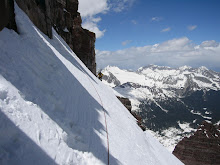
And this is what she was looking down at, the west face of Massive towards North Halfmoon lakes and beyond.
Upon toping out on the ridge, I realized that I had made it that far, and that the summit was not too far out of reach. Why turn back now? I am in good health, physically and mentally, the weather is hold great, and we still have quite a bit of time left until nightfall. It was an obvious and quick decision. To reach the summit on Massive after topping out on the ridge, there are several false summits to climb and descend. It is very much like a roller coaster. Up and down. Up and down. Reaching the top of one, only to find that there is still yet, another one. We reached the summit around noon. Honestly, a really late summit time for Colorado in the middle of July. The rest of our group was there waiting on us, eating, hydrating, and celebrating their accomplishment.

My 2nd 14er! I was really happy!
The next set of pictures is from the summit.


The ridge back down.


Leadville, Colorado. Elevation of 10,152 feet above sea level.


I think that this is one of my best shots. Although it was not taken on the true summit, just a few feet shy of 14,421 feet.
The journey down was long and mostly uneventful. I took a few shots and this was the outcome:

Getting close to exiting the ridge.

Around the corner to grandmother's house we go!


Still a little snow up there.

I really like this shot. The trail as it leaves the ridge.

A good view of La Plata's north face. It was only 3 weeks ago that I was standing on top of it!

Another gully on the west face.

Cliff bands on the west shoulder of Massive.

A parting shot, as we said our fairwells, and then she jumped!
Just kidding!
After a very long day, we made it back to the trail head at 3pm. Climbing is becoming more and more of a passion for me. The people that I meet on the trail are some of the best people in the world. There are very few mountaineers that will not go out of their way for someone else. I long to be in the mountains, and experience all that they have to offer.
La Plata on June 26, 2009 Part 2, The Descent
With storms brewing and moving in our direction, it was time to get down, fairly quickly. Most of the people I ran into were hiking the Northwest Ridge. It was mostly an uneventful hike back down the ridge. I moved as fast as I could with the weather dancing around. As I neared the saddle and the steep, loose trail that lead into the amphitheater, I started getting really hot. I still had my gore-tex layers on from the cold and windy summit, but I didn't want to take anytime shedding them, possibly allowing the storms to truly come alive. By the time I got back to my tent at 12,500 feet, I felt really sick. A lack of nutrition combined with the physcial activity involved with climbing, made my stomach quite upset. I hurriedly packed my tent and camping gear, and began the hot trek all the way back down to the trail head. About every 100 yards or so, I would stop and have dry heaves. Not too sure why, but I think that it had a lot to do with the way in which I treated my body that morning. Not wanting to get caught in a downpour with lightning around, I made as few stops as possbile; getting back to my truck just as the flood gates opened, and mother nature began unleashing her fury. Here are the pictures:

From the trail head looking south towards Huron, 14,003 feet.

A view west along the trail before reaching the amphitheater and treeline.

South again at roughly 12,000. Huron is in the distance.

My first view of the cliffs and ridge that make up the headwall.

Getting closer to a high camp. What appears to be La Plata on center stage.

A good view of the heart of the amphitheater.

From left to right: Browns Peak, Huron, and the Three Apostles, with Ice Mountain being in the middle.

View of Huron and the Three Apostles from my high camp at sunset.

Another later shot of sunset.

Cresting the saddle in the ridge the next morning, Saryes Benchmark comes into view. This is the same mountain that was at the head of the valley that weeks before, me and Richard made our attempt in.


On top of the ridge looking down on the amphitheater. The tiny blue speck in the shade is my tent!

Looking up the ridge at what is hopefully the summit.

Looking back at Sayres and the saddle. Sayres is such a classical looking mountain.


Reaching the top, only to find that we still have a long way to go!
The remainder is views from the top.


I hope that you all enjoyed the post.
Subscribe to:
Posts (Atom)