Wednesday, December 23, 2009
The Avalanche Encyclopedia
A great link to a site that gives basic definitions to the terminology involved in avalanches. The Avalanche Encyclopedia is one to bookmark. I have added it to my links.
Tuesday, December 22, 2009
Pemmican recipes
I been searching for a new source of food while in the backcountry. One that will neither melt, nor freeze into a concrete block. The old standbys, Cliff Bars and Power Bars, are getting real old, so I need something original. While reading stories of expeditions in the Himalayas, I came across countless examples where Pemmican was used as a staple. A quick google search revealed that the pemmican of today is not the same as yesterdays. Nowadays, Pemmican is a brand of beef jerky. As I continue to search for the pemmican of the new millennium, I will add them to this blog, so that everyone can share. The first one came from this site, EasyFunSchool. Pemmican, in it's purest form, is a very simple and often easy to make concoction. The most important ingredient has got to be beef or venison jerky. Store bought jerky is not recommended. The very thought of having fresh venison as the base, sends my taste buds into a frenzy. I will have to make deer hunting more of an effort next year. This year season has already come and gone. Below, is the recipe from the link above.
SUPPLIES/INGREDIENTS:
1 cup Jerky, either beef or venison
1 cup dried blueberries*
1 cup un-roasted sunflower seeds or crushed nuts of any kind
2 teaspoons honey
1/4 cup peanut butter
DIRECTIONS:
1. This version uses peanut butter rather than melted lard as the binding agent, which is much better suited to today’s tastes and need for conscious diets.
2. Grind [or pound] the dried meat to a mealy powder.
3. Add the dried berries and seeds or nuts.
4. Heat the honey, peanut butter until softened. Blend.
5. When cooled, store in a plastic bag in a cool dry place.
Supposedly this will keep for months, but it doesn’t last long at our house. If you can’t find or use dried blueberries, please feel free to use other dried fruits. You can used dried cranberries, raisins, applies, apricots, peaches, etc.
Also, I found a really good blog about surviving day to day. Here is the Daily Survival take on pemmican. It is a little long to paste here, so you'll just have to follow the link. Lastly, The Campfire has a nice write up with step by step pictures for those of us that have yet to learn to read!
Monday, October 26, 2009
You might be a mountain climber if....
You might be a Mountain Climber if...
1. You own a $75 dress suit and a $1000 Gore-Tex suit.
2. You have ever frozen your lips to an ice screw while blowing an ice plug at your partner.
3. You have ever used an ice axe to chop weeds in the garden.
4. You have more summit pictures than wedding pictures.
5. You've ever had icicles hanging from any part of your face.
6. You've ever fallen so far that you've run out of adrenaline before you ran out of rope.
7. You say "Namaste" instead of "Hello."
8. You like the smell of burning yak dung.
9. What you call cold is not on the thermometer scale.
10. When you hear the words "nose," "captain," or "aid," your hands start hurting and swelling.
11. You arrive at a climbing gym with stoppers and cams still in your bag.
12. You hear the name "Hillary" and think about Everest instead of the Secretary of State.
13. And finally, you understood all the previous lines. If you laughed at any of these lame lines, then you should definitely get back to work.
Wednesday, October 21, 2009
Missouri Mountain Oct 18th
 My brother came up from Austin on his way to Billings Montana to buy a pick up truck. The first weekend he was here brought freezing temps and icy conditions around town, making normally a short hop from Lubbock into a very long day. He was more than willing to give up his rear wheel drive car for a 4wd truck. Bekah's birthday party was on saturday, the 17th, until noon, and after that we were free to go climbing. I wanted a relatively easy climb mixed with a backpack and camp in above tree line. The Elks were pretty snowed under, the Front Range climbs seemed a little too short, and the Sangres were a bit too far of a drive. And that left us with the Sawatch Range. We narrowed it down to either Harvard or Missouri. They both seemed like good choices.
We left town around 230pm after a stop at REI and Mountain Chalet for Jay to pick up some last minute supplies, like a new backpack, which by the way, is totally awesome! I need one of those now! We arrived at the Missouri Gulch trail head at about 5pm and were geared up and ready to hit the trail by 530pm. The sun had already set behind the mountains, as we began our race to beat darkness. It was a clear sky, with warming then normal temps. About half way up the trail, darkness took over and it was time to turn on the headlamps. We still had not reached snowline yet, but from the view at the parking lot, there was a lot of snow up there.
 We made it to camp at 11,000 feet and found a place to pitch our tent on some soft snow, and sheltered from the relentless wind. Once dinner was ate, we crawled into our bags for a cozy night winter camping style.
The view north across the valley where my truck is parked.


The next morning, we woke up extremely late, which we found out later in the day, would prohibit us from making the summit. The alpenglow on Missouri was a
spectacular sight, especially with all the snow. This is the view from our campsite, out away from the short, stubby trees.
 Mount Belford's Northwest shoulder, standard route. I climbed this route last August, in winter like conditions, ice and snow!
A closer view of Missouri, the summit is roughly in the middle, out of sight behind the ridge.


The route we intended to climb is starting to receive it's morning sunshine. It is behind the shoulder that is in the middle of the picture coming off of the large mountain on the right, still in the shadow of Belford.
A closer view of the sub peak along Missouri's North Ridge.

Jay and me geared up and ready for the climb, as we leave camp at roughly 830am; extremely late in the morning!

As we hike further up the basin, we begin to realize just how much snow is up there.

I am not too sure of the name of this sub-peak, but it has some interesting lines to climb.

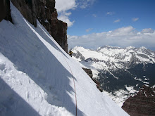
 Jay, taking his turn of breaking trail in the snow. Missouri's impressive North Face is behind him. The trail would come and go, as we tried to follow it the best we could. The day before, a couple descended from Elkhead Pass, at the head of Missouri Gulch. We tried to follow their tracks, but they would often go through deep snow, which was difficult to climb up.
 Me, with Missouri behind and Elkhead Pass behind a shoulder off of Belford on the left.
 Another cool looking pic of Jay.
Another shot of me with a cool looking shoulder that would be fun to climb.

Contemplating a climb for another day.

The creek would appear and disappear under the snow. It was really cool to see the ice formations within the creek.

We made it to the sign for the turnoff to the standard route up Missouri, roughly a mile and half from camp. The sign is visible at the base of the cliffs in the foreground.

Jay crossing the creek on a snow bridge.

A closer view of Missouri's East Shoulder, the standard route is up the ramp to the left of the rocks.

At the turnoff to Elkhead pass, below the route up to the ridge. We decided to opt out of this climb for various reason. One being that it was really late in the day, roughly 1130am, and two, the snow was not stable. We noticed several avalanches high above on Missouri. The more we hiked up into the basin, the more slides we could see. none were large, but they all could be damaging to anyone caught in one.

Jay, looking up at a future climb, and wondering what the summit looks like.

Here is two more of a close up on the North Face Couloirs.


Given the time of day and the work involved in a retreat back to camp, we called it a day. Turning around from such a beautiful, but a dangerous place is always hard to do, but it must be done. The return to civilization begins. We made it back to camp by 130pm to an open tent. Apparently, we forgot to close up the tent before we set out earlier in the morning. Luckily, nothing was missing or chewed up. Arriving at my truck at 330pm was a sad, but a relief to be there. A bad day in the mountains is always better than a great day back in the real world. I look forward to many more climbs and boundless mountains. My next adventure will be over Halloween weekend, maybe I can act more like a true mountaineer rather than dressing up like one!
Monday, October 5, 2009
Fall in Colorado, Mt Yale attempt
 Well, it looks like fall has finally arrived and is planning on sticking around for awhile now. No more of those 80F days. Over the past several weeks, storm after storm has pounded the high country, but it has always been followed by a dry, warm spell; melting all the fresh snow. But, now it seems that the new snow will be sticking around! Maybe this will make a great base for our winter snowpack. Down here in the springs, we have already had a taste of early winter. Last week we had our first freeze and snow of the season! And it was in September! Boy, am I ready for it.
Last weekend was suppose to be a weekend of climbs. But as the ball rolled on, it seemed that nothing was accomplished. I had originally planned on to hike in to Horn Fork basin below Mt Harvard on friday after work, then make a climb up Harvard on saturday am, eventually leaving the sawatch range that afternoon for the elks. Thoughts of Castle Peak loomed in my mind throughout the week and into the weekend, for that was going to be the climb of climbs for me. I looked forward to a weekend full of climbing! What happened? As work often lingers beyond the time it is suppose to, fridays can never be early, nor can I ever get off in time for anything on that day. Thursday brought a slow day at work and thus I was at home by 11am, hoping that the next day would follow it's lead. I should have known better.
By the time 130pm on friday came around, it was too late to try to drive somewhere and then hike in 3 to 3.5 miles and set up camp before dark. I'd be lucky to have camp set by 9pm, roughly 2.5 hours after sunset. Now, I had to come up with a "plan B", and quick! Mount Princeton looked to be good climb and warm up to Castle Peak. Ok, I've got a mountain in mind, now what? I wanted to start the climb a little bit before sunrise, so that I could maximize my day, and enjoy a glorious sunrise above treeline. 430am seemed doable, but I still would have to drive 2-1/2 hours from home to get there in the middle of the night. Doable? Well, maybe.

The alarm went off at 245am. I struggled to crawl out of bed and gather myself up. I arrived at Buena Vista at 445am, and was bound and determined to get lost on the road to the trail head. I made wrong turn after wrong turn, eventually getting frustrated enough to call it quits. Now what? I suppose I had better make a "plan C"! Mount Yale is not too far away, and I know where the trail head is! It was 545am when I pulled into the Denny Creek parking lot, the trail head for Yale. The morning air had become quite cold as the first indications of a new day began to illuminate the eastern skies. I made a quick check of gear and headed up the trail. It was a cool hike, although most would think that 30F is cold, it is relative to the energy output needed to climb nearly 4500 vertical feet all the way to the top.

The first 2 miles gains very little elevation, as it follows Denny Creek up into the deep forest. Emerging from treeline, the wind really began to pick up in earnest; making a cold wind chill, roughly around 15F. I've got to get on a little soap box here about the trail. Up until this point, the trail was a very nice, well maintained trail; but once above the trees, the trail became quite steep, practically straight uphill, on a very loose dirt patch. It was nasty! Up, and up it went. Upon cresting each hill, another steep, straight section of trail would loom over me, as a thorn to my side! The mountain was laughing, as I was struggling to maintain composure. I took a break, and put on more clothes, ate some snacks, and drank water.
Contemplating the never ending dirt patch to the ridge, I was puzzled at what I should do. There were quite a few other groups of climbers ahead of me, the weather was clear and a million, but I was spent, cold, and utterly exhausted. I wasn't sure if I would have any energy left over for another climb on the following day. The decision was not one to come quickly. I fought within my deepest self, to find any reserves left to help push me over the top. But, each time I searched my soul, I would find cold emptiness. The weekend was half over, and I felt I was in a fight with a Spainish bull, and was loosing the battle.
 The look of defeat is never a beautiful sight. As I made plans for a retreat, I began snapping pictures, as a reminder of a mountain that persisted to be unclimbed. I could bare no more, as her walls were too much for the wounded warrior. I felt terrible after putting such a strong fight just to get to 13,000 feet, and 3.25 miles, only 1200 feet and 1 mile short of the summit.
The Three Apostles to the Northwest.

West towards the snowy Elk Mountains. Tomorrows destination?

Cottonwood Creek valley and the trailhead below.

Upper Cottonwood Creek.

Mount Yale Southeast Ridge and more mountains beyond.

Mount Princeton, another 14er, this mornings early plan to climb, but I couldn't find the right road in the middle of the night!

A close up of the remainder of the route up to the ridge proper. It is much steeper than it appears.
After an hour and half decent, I was back at my truck stripping off layer, upon layer of clothing and insulation from the cold tundra above. I packed my belongings, and picked myself up from defeat, and headed into town for a nice hot meal. K's Dairy Mart, was on the horizon. A #2 please, no onions, and a large Coke! Oh Boy! Nothing like a fat double cheeseburger with bacon, complimented with fries and a Coke to wash my blues away. I made a few phone calls to fellow climbers concerning a climb of Castle the next day. The weather report did not look too good, and I felt like crap. The next horizon will take me back home to the reality of Colorado Springs and to my loving family. Castle will have to wait for another day, more than likely a day next spring!
Tuesday, September 15, 2009
Sunday, September 13, 2009
Colorado Highest, Mt Elbert

This weekends climbing schedule was a little tricked up. I had originally planned on the Castle and Conundrum idea, but could not find anybody to go with. That climb is best done with another person, and not solo. So, I had to look at other peaks that I could climb solo that fit the criteria; close to home, decent weather (no t-storms, or white out snow conditions), and class 2 climb. There is plenty of peaks within a 3 hour drive to Colorado Springs, but none as close as our own, Pikes Peak. It would have worked well, but the weather forecast for the Springs was pretty grim, and the summit forecast was much worse. 70% chance of snow, up to 3 inches during the day, and another 3 to 5 overnight, and high temps around 30F. Definetely winter, but I wanted one more summer climb before winter takes hold of the high country, plus I also wanted to see how the Fall colors were coming along around the central mountains. The East Trail of Mt Elbert fit the bill. With a 30% chance of rain/snow showers and "some thunder possible", and highs around 50F, it was the best forecast for 14ers in Colorado.
By the time I got things ready to go on Friday, it was too late to leave for the mountains. And we BBQ'd friday night with our neighbors until 11pm. So, there was no way I was going to get up at 1am and drive 3 hours to the trail head in the dark, then climb for 2 and half hours by headlamp (note. also in the dark). 3 hours of sleep is not enough to climb any mountain, let alone a 14er. Instead I set the alarm for 230am, and boy did it come around quick. I felt like I just went to bed, so I turned it off, giving up on the idea of climbing, and fell back asleep. Around 530am my body woke up and said "if your going to climb something today, then now is the time!". So, I listened, and left in 15 minutes.
Leaving the Springs, I still had Pikes on my mind. After fueling up in Divide, I sat there in the cold 36F weather, pondering and looking over at Pikes. It was 645 am, and I would have another 2 hours drive to the Elbert trail head, putting me on the trail at 9am. Really late start! Where as I could be on the trail for Pikes at 7am, 2 hours earlier than Elbert. But what about the weather on Pikes? Naw... Elbert or bust! Here I come! Watching the weather move in towards the front range on the drive out, assured me that I had made the right decision.
I arrived at the trail head at 9am and began hiking at 915am in brilliant sunshine. The trail begins in a very large forest of aspens, and most of them were changing to their fall colors. As I climbed through the forest, the sun was overtaken by dark clouds, and the wind began to pick up some. Upon reaching tree line, the objective became clear, just as the snow/sleet began to come down. It was too warm for it to stick to the ground. Continuing up, the squalls would come and go, as with the visibility. It was never bad enough to turn around, as I could still clearly see the trail ahead, but the surrounding mountains would disappear. This trail to the top of Colorado is pretty straight forward, just follow it until it ends. I summited at 1pm amidst half a dozen other people. There were stronger storms to the north and also to the south, whereas only scattered snow was to our west, the general direction that the weather was coming from. After a quick snack, it was time to descend, before the weather changed it's mind. About half way to tree line, loud, crackeling thunder began to roar behind Elbert, and I knew it was coming my way. I scurried as fast as possible down the steep trail, to the point of almost jogging, racing the impeding storm! If I could only get to the trees before it hits, then I'd be safe! Reaching treeline, I turned behind to what I thought would be the storm of all time, only to see light snow/sleet falling on the ridge behind me. The storm had just missed me by one ridge! Whew, that was close! Descending further into the forest, I had to shed my winter layers and return to fall like weather. I reached my truck at 330pm, roughly 2 hours after I left the summit. It was a fairly uneventful drive back home, until I reached Wilkerson Pass, where the rain began to come down hard. Reaching Woodland Park, the clouds dropped, as thick, soupy fog settled in, and flashes of lightning were all around. I met my family at Black Bear Diner for a nice big breakfast supper. Here is the pics from the trip.

Thick aspen forest on the trail

Mt Elbert is finally in sight

Closer to the East Ridge of Elbert

On the East Ridge looking across the basin to the North Ridge

Mt Massive, 2nd highest, and my 2nd 14er

Looking down into the East Bowl

Twin Lakes and Independence Pass road from high up

First view of La Plata, 4th highest and my 1st 14er

Looking down the North Face

Highest point in Colorado, Mt Elbert summit

La Plata with storms boiling to her south

Northeast from the summit

View North from the summit, Mt Massive and North Halfmoon Creek drainage

View Southeast towards Buena Vista and Twin Lakes

Official summit USGS benchmark, 14,433

Looking roughly West from the summit

Across the Arkansas River valley, with Mt Sherman about to be stormed on
Subscribe to:
Posts (Atom)